This week started on a high with me putting a big fat beautiful tick next to one of the items on my bucket list and finished with a walk up my least favourite hill – Bleaklow.
I’m not entirely sure why it’s my least favourite hill. It’s not the furthest one away from where I live, making it difficult to get to. It’s not the highest, steepest or most difficult to climb. It’s not the boggiest. It’s not teeming with midges. It’s not rampant with fair-weather-hiking muggles.
Maybe it’s the eerie and desolate crash site. Maybe it’s just because my pal, Rich, said it was his ‘least favourite hill’ when he first introduced me to it? Maybe it’s because I’ve just not traipsed off across that many sh!t-boring hills to gain a proper frame of reference?
It’s just a bit ‘bleak’ !
It’s just a bit ‘low’ !
It just a whole lot ‘meh’ !
Although saying that, I’ll probably find some meandering way to scrawl a few thousand words about the walk. And starting off saying ‘this is my least favourite walk’, isn’t the best thing to do to keep my occasional reader interested. Good job I don’t make my living as a marketing professional… Doh!
‘The Walking Dan’, my faithful walking companion, was my trekmate for the day. He’d been wanting to try Bleaklow again for ages and I’d put it off as long as possible, but the joyous events of the start of the week meant that nothing could get me down – not even my ‘least favourite hill’.
Our previous Bleaklow walk hadn’t gone well and our attempt to find the plane crash site had failed. It had failed due to it being fiendishly windy and foggy that day and we had no means of navigation other than my vague memories of where it was from my trip with Rich previously. In our defence it was so foggy that I would have probably have struggled to find my arse with both hands. We did find a Park Ranger though and asked him if we were close. He’d stumbled out of the gloom, on The Pennine Way, with all the proper kit, and a map, and a compass, and a dog. He gave us, predictably and fairly (and condescendingly smugly), a bit of grief about disrespecting the mountain (mountain? really? WTF?) and that he didn’t want to be calling Mountain Rescue out for us later that day when we got lost. The weather wasn’t getting any better and after deliberately walking the opposite way to the directions the Park Ranger had given us, until he was out of site – just to wind him up, we’d called it a day and headed back.
This time we were prepared. ‘The Walking Dan’ had GPS! Boom!
Well… sort of prepared. I think I’d set my brain to ‘lets not go on this walk’ mode, as I’d certainly hadn’t set my alarm the night before. Thankfully (I think!), I woke up at exactly the time I’d planned on leaving the house. It must be all that military (Call of Duty!) training. It’s about a 50/50 chance that I prepare everything for a walk the night before and this was one of them so I was out the door 5 minutes later heading toward Holmfirth and the bleakness beyond. It was an earlier start than usual, 5.45am as I needed to avoid a stint in the doghouse and be finished in time to take the family to my niece’s birthday party that afternoon.
In theory, Bleaklow is only around 30 minutes away and I’d allowed 45 minutes to make the trip. So, even with my meagre grasp of mathematics, I knew I had time to stop and grab the breakfast I’d missed at home on the way.
Holmfirth, and the surrounding area, was the setting for the TV series ‘The Last of the Summer Wine’, something I thought was hilarious as a child. However, once I’d hit the age of 12 I realised that it was a steaming pile of telly for old people and those that don’t know any better. It was never the same when Compo and Foggy left anyhow. I do have a guilty secret though of wanting to watch it again to try and identify all the places I’ve walked in recent times. It’s also the gateway to the Southern Pennines and my route today took me through the small town and onwards through Holmbridge and up to the top of Holme Moss. Holme Moss is one of the highest points in West Yorkshire and the location of the Holme Moss Radio Transmitting Station, a huge tall and thin radio transmitter that can be seen from miles around. The views from here over towards Huddersfield are sensational and it’s well worth a visit just for that, let alone using it as a starting point for a walk. It’s also memorable for the insane scenes during the Tour De France when seemingly everyone in the whole of Yorkshire came out to urge the riders up and over the hill.
It wasn’t my destination today, I carried on over the top for my first view of Bleaklow and the Longdendale Valley. Or not… as there was a Table Mountain-like tablecloth of fog and who-knows-what-else covering the entire moorland top. From here it should have been a quick and easy drive down towards the A628 Woodhead Pass and then across the landbridge between the Woodhead Reservoir and Torside Reservoir. Quick and easy normally, but not today of course as I was on the clock. The road across the landbridge that led to our walk start point at the Torside Res Car Park was closed and diversion signs pointed off down the A628 towards Glossop. ‘The Walking Dan’ himself was here having just driven down the road to see if there was a sneaky way through. There wasn’t so we headed off, in convoy, past Crowden and towards Glossop hoping the the lads in charge of putting the diversion signs in place had done their jobs. They hadn’t – ‘the w*nkers’! So I pulled to the side of the road in Hadfield and put the car park’s postcode into Sally SatNav and quickly set off again.
This was turning into a tour of slightly sh*t comedy series locations! Hadfield is in fact, Royston Vasey, the setting for the League of Gentlemen black comedy. I didn’t want to hang around in case I got a nose-bleed or the pig-nosed Royston Vasey inhabitants realised I wasn’t ‘local’ and used me for sausage-filling.
Hadfield, turned into Padfield and ignoring the Gandalf-like ‘YOU SHALL NOT PASS’ and ‘YOU SHALL NOT PARK’ road signs we ended up parking by the side of the Trans-Pennine Trail, wedged up against the banking at the bottom of the private road leading to Reaps Farm.
We were half an hour past our planned starting point, so we kept our usual getting-ready-faff to a minimum (which meant I forgot my coffee and water supplies) and finally started off up towards Bleaklow.
Bleaklow isn’t that low actually, at 633m it’s the second highest lump in whole of The Peak District, just slightly smaller than Kinder Scout. And bizarrely, given its seemingly central location it’s the highest most easterly point in the British Isles… how about that? It’s infinite bleakness sits straddled between the cross-Pennines routes of the aforementioned Woodhead Pass and Snake Pass both of which connect Sheffield to Manchester. None other than the walking deity that is Alfred Wainwright said of Bleaklow ‘All who are on it are glad to get off it’ so it’s not just me that ain’t a fan. Wikipedia mentions that Kinder is the parent of Bleaklow, but the apple has definitely fallen far from the tree here and Kinder should probably go get a DNA test and having some serious words with the other parent as to what they’ve been up to, and with whom!
We headed up the track past Reap’s Farm with The Walking Dan glancing enviously at the farm’s architecture and took the path leading upwards overlooking Torside Clough. This was the steepest climb of the day, so heads down we kept chat to a minimum and got on with it. There’s a lower path up to Bleaklow that runs alongside the Clough itself, but it quickly turns into a scramble as the terrain steepens and I’ve seen more than a few walking parties struggling up it. Up high the views of the Clough are spectacular, as is the view back over the Longdendale Trail and Res towards Crowden. But, not today unfortunately as the rain started to pour and what little view we had slipped into the gloom and vanished. Waterproofs were quickly put on, but we soon wished we were wearing suits of armour as a heavy shower of hail battered us for the 20 minutes or so as we struggled along the small slippery path on the side of the hill.
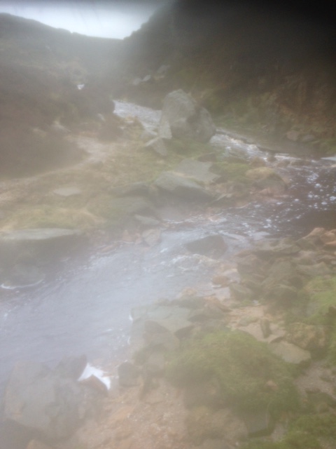
Top of Torside Clough
‘The Walking Dan’ had said there was a ‘Castle’ nearby, but when I asked if it was a real castle or a made up one like Alports Castle he went all quiet, so we didn’t go to see what Torside Castle was all about! It was still doom and gloom as Torside Clough narrowed and we scrambled down and across it to join the path up towards Bleaklow Head. This part of the walk always takes longer than I expect and by the time we reached the cairn at Bleaklow Head the sun had peaked through the clouds and there were patches of blue sky too.
We found a reasonably dry perch on the cairn and treated ourselves to coffee and an experimental cake I’d made the day before… a madeira-esque thing with all kinds of randoms in it (cranberries, walnuts, goji berries and blueberries). Dan kindly said it didn’t taste terrible, so suitable caffeined and sugared up we mentally prepared ourselves for some GPS action.
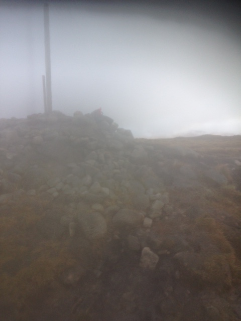
Bleak, Bleak, Bleaklow Head
At some point on Bleaklow you will go ‘off the track’, either by design or by default. Normally the map-reading skills of ‘The Walking Dan’ mean it’s the latter, but today Garmin was in charge and it was saying it was time to go OTT. And Garmin needed to be in charge as the gloom had returned and the mist had swept in giving the desolate landscape around Bleaklow Head an eerie feel to it.
We were heading towards the crash site near the trig at Higher Shelf Stones. In normal conditions you can guide yourself by eye, walking from the Wain Stones to Hern Stones and then on from there. Today, we couldn’t see the Wain Stones because of the mist and so they were left to keep on trying to kiss each other in peace. The next half a hour was a GPS-led scramble through a series of gruffs (water eroded peat channels) and a few hop, skips and jump competitions across the boggetry that connects the Wain Stones to Hern Stones. Higher Shelf Stones was barely visible in the distance, so we took a bearing again and set off, through gruff after gruff after bog, towards it, hoping it wasn’t a mirage. It’s not quite as bad as a Kinder Scout gruff crossing, but still a pain.
We came across the crash site just before Higher Shelf Stones.
There are a number of other publicly accessible smaller crash sites in the Peak District, but this one is quite substantial, with wreckage strewn over a large area. It’s a sobering and thought-provoking discovery, both peaceful and disquieting all at the same time. A memorial marks the spot where a Boeing Superfortress, en-route from Scampton in Lincolnshire to Burtonwood in Lancashire crashed, killing all 13 crew members.
‘The Walking Dan’ and I had both seen a trailer for a ‘as yet unreleased’ horror film called the ‘Dark Peak’, shot in various parts of The Peak District. In the gloom and mist, amongst the wreckage of the plane, it was playing on my mind, so I wasn’t going to take too many pictures or linger too long. There’s plenty of images of the site available online if you do a Google search. And if you want to give yourself nightmares you can watch the short trailer of ‘Dark Peak’ by clicking on this link… you’ve been warned!
I was still thinking about the movie and about to make a sharp exit when two shapes materialised out of the gloom in front of me, scaring the total crap out me. Just two hikers slightly lost, looking for the Pennine Way… or was it? Girl or ghoul?
Taking no chances, I signaled to Dan that it was time to move on and we shuffled away towards the trig point at Higher Shelf Stones. Normally there’s a great view from here over Coldharbour Moor, Snake Pass and onto Kinder, Mam Tor and the rest of our usual stomping ground. But, not today, we could barely see the Stones themselves or our hands in front of our faces. We could see the graffiti cut and carved into the Stones though, a whole job lot of it. Much of it was from the war years, including a huge one proclaiming that ‘L Chadderton’ was there in ‘1940’. There were also some going back as far as the 18th Century – although I did spoil our musings by suggesting ‘1745’, might just have been someone’s favourite time of the day!
Our route back was going to be via The Pennine Way and our new best friend, Mr Garmin, indicated that all we needed to do was follow the curvature of the hill away to the north east until we hit the path. As we did the mist cleared giving us a cracking unrestricted view, for the first time that day, away over Alport Moor. The way to The Way was cross-country but arguably the easiest 10 minutes of the walk and we soon found ourselves back on track and returned to Bleaklow Head without too much fuss.
The mist and fog and gloom had cleared by this point so after another brief coffee break we were on our way admiring the view across the desolation and into civilisation (well, as much as Lancashire can be described as civilisation that is!).
We retraced our steps back to Torside Clough and with the view cleared we were seeing things impossible to see on our outbound journey. I spotted what I thought/hoped was a volcano caldera or a meteor strike, but ‘The Walking Dan’ brought me down to earth and reality by saying it was probably a quarry. Google confirmed it was man-made, a gritstone quarry, but just for a moment the thoughts of Peak District volcanoes were good ones. A promise was made to trek up to the meteor-volcano-quarry at some point in the future.
We made it back to the cars in good time, which thankfully hadn’t been towed or clamped because of improper parking, and had a spot of lunch overlooking the reservoir. Then for me it was then on to my niece’s birthday and reliving the high that had started the week off.


My football team, Barnsley FC had won a trophy at Wembley, coming from behind to beat Oxford United 3-2. Sure, to the rest of the world it was ‘just’ the Johnstone’s Paint Trophy, but to a set of fans that had been starved of any kind of success for a decade it was awesome. I’d actually done an ‘impossible list’ at the end of 2015 detailing over 100 things I wanted to do if little things like time, money and the laws of the universe didn’t apply. One of them was to ‘watch Barnsley win a cup at Wembley’, which I thought was as improbable as some of the others – ‘visiting a parallel universe’, ‘sh*gging Kylie’ and ‘captaining the Starship Enterprise’. It just proves that some dreams can come true.
